Google Earth is an amazing thing, and it’s hard to understand what’s truly going on in the Timor Sea simply by looking at pictures, so I’ve created a Google Earth collection that shows the coordinates provided in the major treaties affecting the region: the 1972 Indonesian-Australian Seabed Boundary Agreement [PDF], the 1981 Provisional Fisheries Surveillance and Enforcement Arrangement [PDF], the 1989 Timor Gap Treaty, the 1997 Water Column Boundary Agreement, the 2002 Timor Sea Treaty, and the 2006 Sunrise IUA/CMATS.
The Google Earth collection for the Maritime Boundaries in the Timor Sea can be downloaded here.

if you display all of the treaties at once, it kind of looks like a rainbow threw up in the Timor Sea
If you’re interested in figuring out how all these treaties work together, it is probably more useful to just go ahead and play around with it on Google Earth, but I’ve provided a visual summary below using screencaps from the collection.
I. The Indonesian-Australian Seabed Boundary Agreement (1972)
In the beginning, there was the gap:

1972 Seabed Boundary, with coordinates
Australia and Indonesia entered into the 1972 seabed boundary treaty, which established a maritime boundary that was significantly north of the median line between Indonesia and Australia. The boundary in front of Portuguese-controlled Timor remains unfixed.
In 1975, Portuguese exited the scene, and Indonesia promptly invaded. Indonesia and Australia try, and fail, to enter into an agreement establishing the maritime boundary between Australia and Indonesian Timor.
II. The PFSEL (1981)
In 1981, Indonesia and Australia still had not entered into any permanent treaty arrangements over their maritime boundaries, but they did succeed in reaching a Memorandum of Understanding concerning the Provisional Fisheries Surveillance and Enforcement Arrangement. This MOU did not establish any agreement as to the seabed resources, but provided a working arrangement for other maritime concerns in the region by establishing the Provisional Fisheries Surveillance and Enforcement Line (PFSEL). The PFSEL was drawn roughly along the median between the coasts of Timor and Australia, and this line would later be largely replicated as the water column boundary in the 1997 Treaty between the Australia and Indonesia, establishing an Exclusive Economic Zone Boundary and Certain Seabed Boundaries
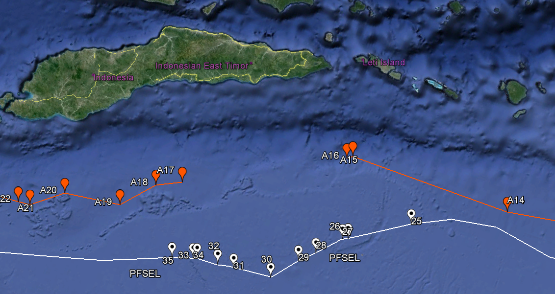
1972 seabed boundary (red) and 1981 PFSEL (white)
III. The Timor Gap Treaty (1989)
In 1989, Australia and Indonesia entered into the Timor Gap Treaty, which came into effect in 1991. The TGT, if taken in a generous light, could be described as a “creative compromise.” It was ultimately reached by simply setting aside the question of maritime boundaries, and instead establishing three “zones of cooperation” in which Australia and Indonesia could jointly produce the petroleum found in the disputed Timor Sea region. Tax revenues from Zone A were split between Australia and Indonesia 50%/50%; in Zone B, Australia paid Indonesia 10% of the tax revenues it collected; and in Zone C, Indonesia paid Australia 10% of the tax revenues it collected.
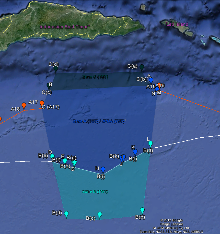
The three ‘Zones of Cooperation’ established by the Timor Gap Treaty (1989)
The coffin-shaped design of the Zone of Cooperation Whole (“Zone”) was a deliberate choice made by Indonesia and Australia, and it does not directly reflect maritime boundaries that would be suggested by international law. Essentially, the parties agreed that the widest part of the Zone would be placed where the “Timor gap” lay, in between the opening left by the 1972 seabed boundary line, and the Zone would then become narrower both to the north and south of the Timor gap.
Northern and Southern Boundaries of the Zone
The placement of the northern and southern boundaries of the Zone has a relatively objective basis. Indonesia and Australia agreed to draw the northern boundary of the Zone directly on top of the deepest point of the Timor Sea — the Timor Trough. The Timor Trough lies approximately 40 nautical miles south of East Timor, and it runs roughly parallel to the Timorese coastline. The northern boundary of the Zone is significant in that it marks the boundary of the most extensive territorial claim that Australia has tried to assert in the Timor Sea.
Australia’s claim to sovereign rights over all of the maritime areas south of the Timor Trough are based on the “natural prolongation” principle. The natural prolongation principle, which has been almost entirely discarded under modern international law, provided that the boundaries of a coastal state’s maritime territory should reflect the ‘natural prolongation’ of its land territory along the contintental shelf, based on geological features of the seabed. Roughly speaking, it provides that a state’s rights to the continental shelf extend until interrupted by some geological feature. Australia has contended that the Timor Trough is the relevant “interrupting” geological feature in the Timor Sea, and therefore its rights extend from the Australian coast line to the deepest point of the Trough:
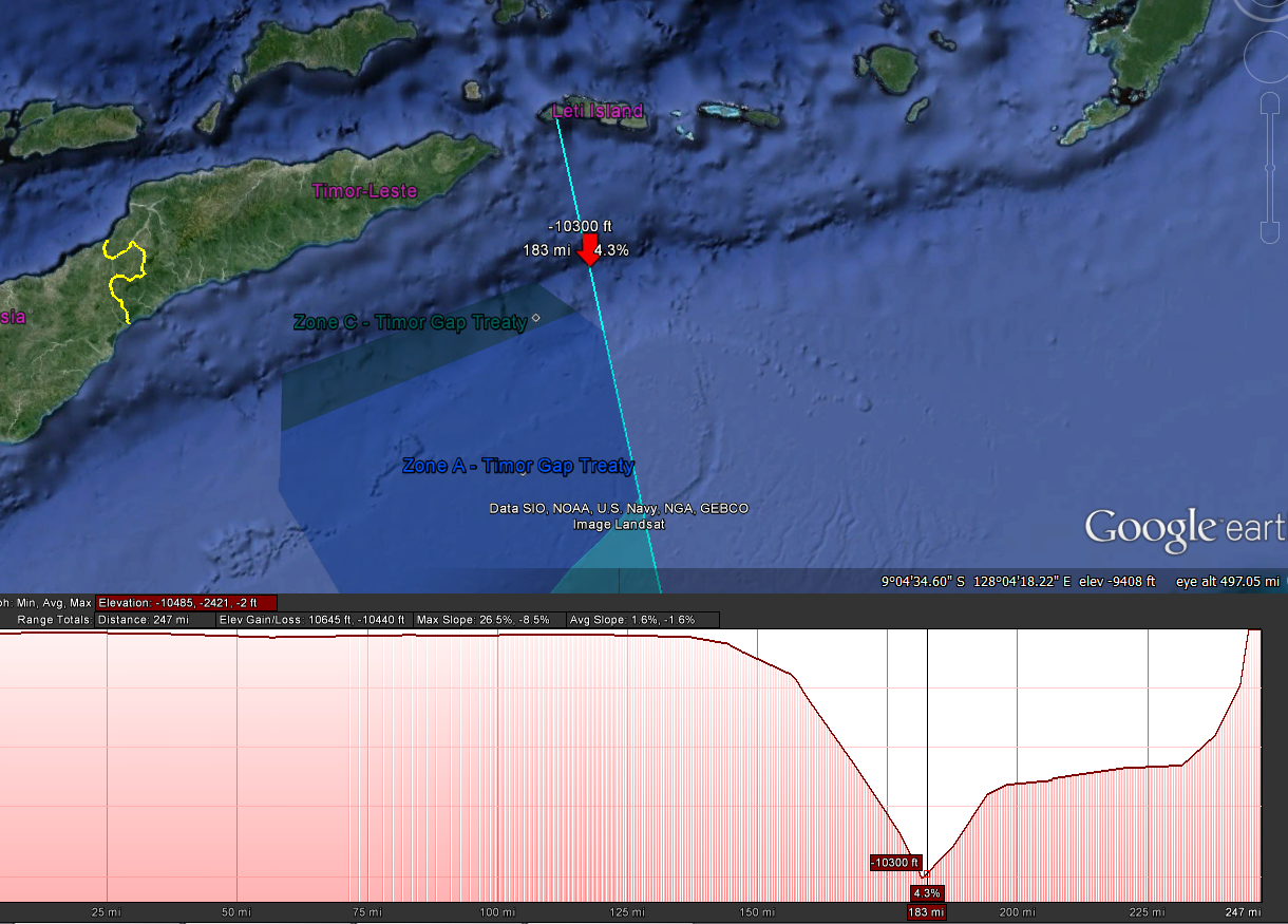
Above: Eastern boundary of the Zone of cooperation (marked in cyan). Below: Elevation profile of the eastern boundary of the Zone. Note that the northern boundary of Zone coincides with the deepest part of the trough.
In contrast to the Zone’s northern boundary, the Zone’s southern boundary is drawn along a line that is 200 nautical miles off the coast of the island of Timor. This represents what is, theoretically, the most extensive claim that Indonesia could have made over the Timor Sea, based on the 200nm exclusive economic zone (EEZ), as established by UNCLOS. When a state has no close maritime neighbors, its EEZ stretches out from its coastal baseline to the 200nm limit. However, when the sea between two adjacent states is less than 400nm (as is the case in the Timor Sea), both states are unable to have a full 200-mile EEZ. In those cases, the EEZ is instead typically drawn along a median line between the two coasts.
Even though the 200nm limit does not technically apply to the Timor Sea, it did provide a useful boundary for Indonesia and Australia to use during their negotiations over the Timor Gap Treaty. In order to set the northern and southern boundaries of the Zone, the parties’ reached an agreement that (at least theoretically) would reflect both Indonesia and Australia’s maximum possible maritime territorial claims.
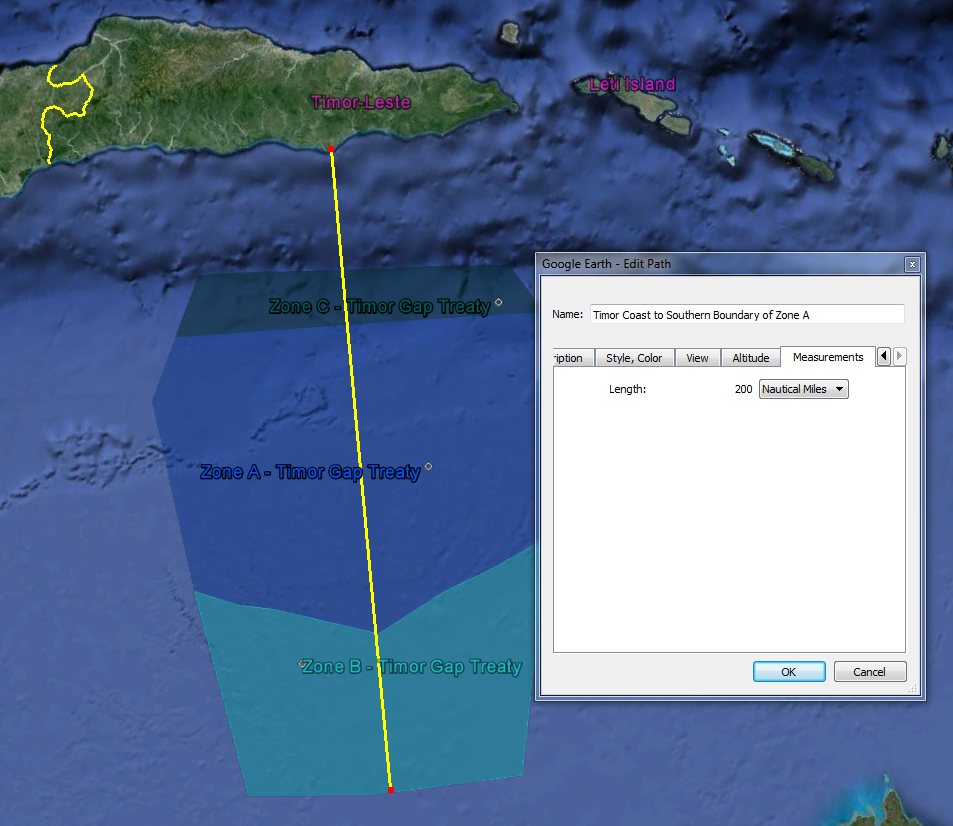
Southern boundary of the Zone (marked in yellow), is drawn 200 nautical miles south of Timor’s coast, running roughly parallel to Timor.
Although the southern and northern boundaries of the Zone were thus, ostensibly, “fair,” in that it was defined by the overlapping areas of each state’s maximum possible territorial claim, the actual result is inequitable in that the Zone lies a mere 40nm south of East Timor’s coast, but lies approximately 90nm north of Australia’s coast.
The Internal Boundaries of the Zone (Zones A, B, and C)
As discussed supra, the Zone is subdivided into three smaller zones, and different economic regulations apply to each of the three internal zones. The division between Zone A (the middle zone) and Zone B (the southern-most zone) is drawn along the median between Australia and Timor. This boundary lies close to — but is not coextensive with — the PFSEL, which is the median line that was established in the Provisional Fisheries Surveillance and Enforcement Arrangement.fn1
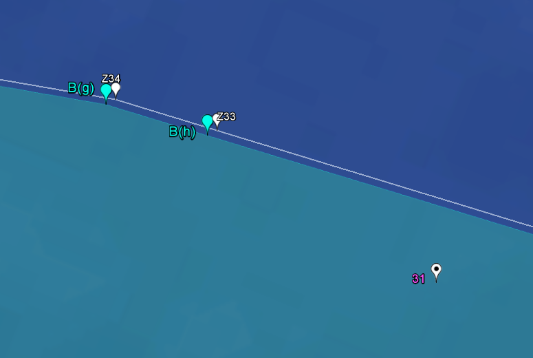
Close-up depiction of the boundary between Zone B (area to the south, shaded in green) and Zone A (area to the north, shaded in blue). The area shown is along the western half of the Zone A-Zone B boundary. Coordinates for the Zone A-Zone B boundary established by the Timor Gap Treaty (1989) are marked by green flags (note: these coordinates are also the same coordinates used in the Timor Sea Treaty (2002)). Coordinates for the median boundary established by the 1997 Water Column agreement are marked by solid white flags. Coordinates for the boundary established by PFSEL (1981) are marked by the black-dotted flags.
The boundary between Zone C (the northern-most zone) and Zone A (the middle zone) lies a little ways north of the original 1972 seabed boundary. The angle of the Zone C-Zone A boundary is dissimilar to the angle of the 1972 seabed boundary, however. The Zone C-Zone A boundary appears to have been demarcated on the basis of seabed features; it largely coincides with a seabed ridge to the south of the Timor Trough, where the southern slope of the Timor Trough levels off. The result is that the northern and southern boundaries of Zone C are not completely parallel, as they are not based on the same seabed feature. The northern boundary tracks the deepest point of the Trough, while the southern boundary tracks the canyon lip of the Trough:
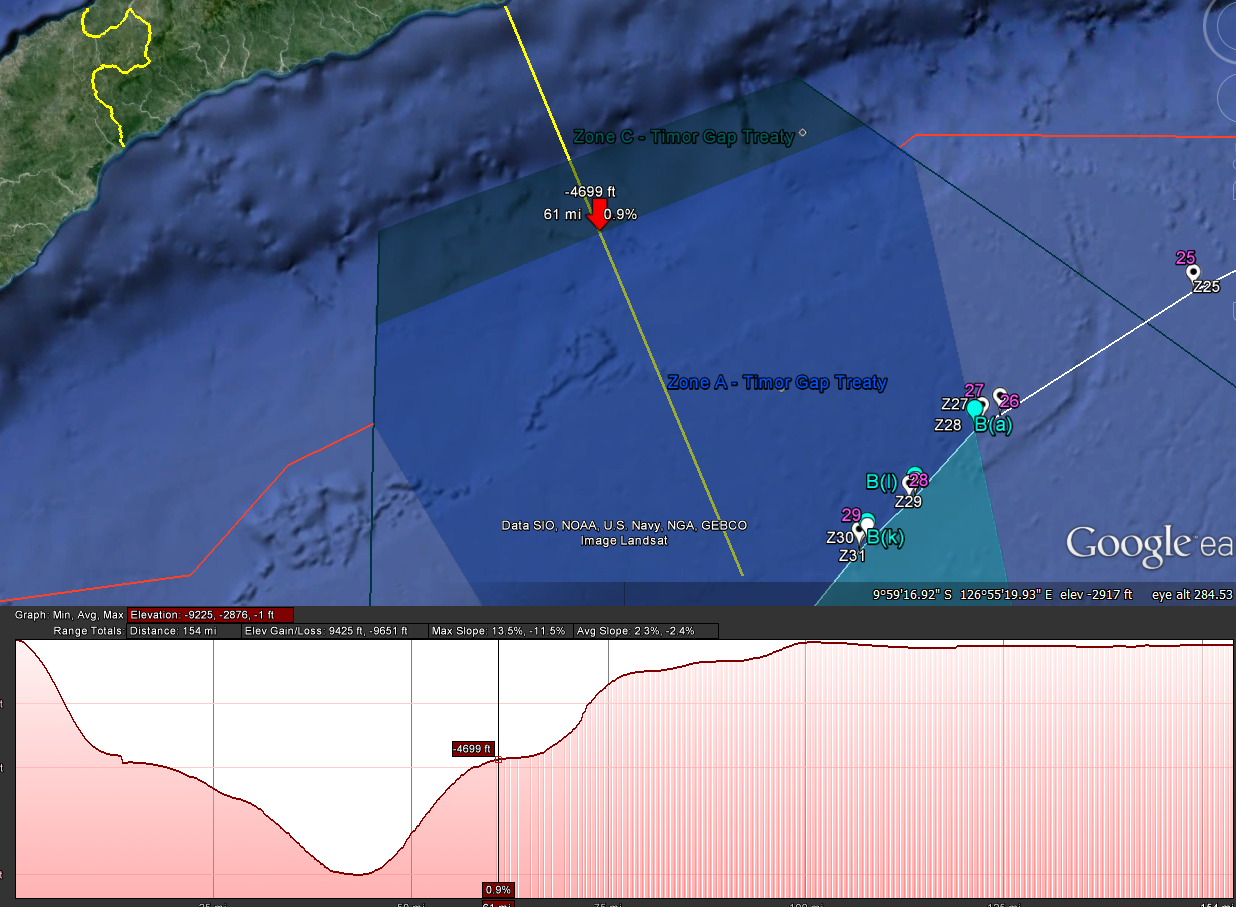
Above: The Zone C-Zone A boundary. Zone C (dark blue area) and Zone A (royal blue area) are demarcated at a boundary drawn on top of the “canyon lip” of the Timor Trough, where the Trough levels off from its steepest drop. Below: Elevation profile of the Timor Sea. Note that the canyon lip of the timor trough corresponded with the red arrow depicted in the above picture.
Western Lateral Boundaries of Zones A and B
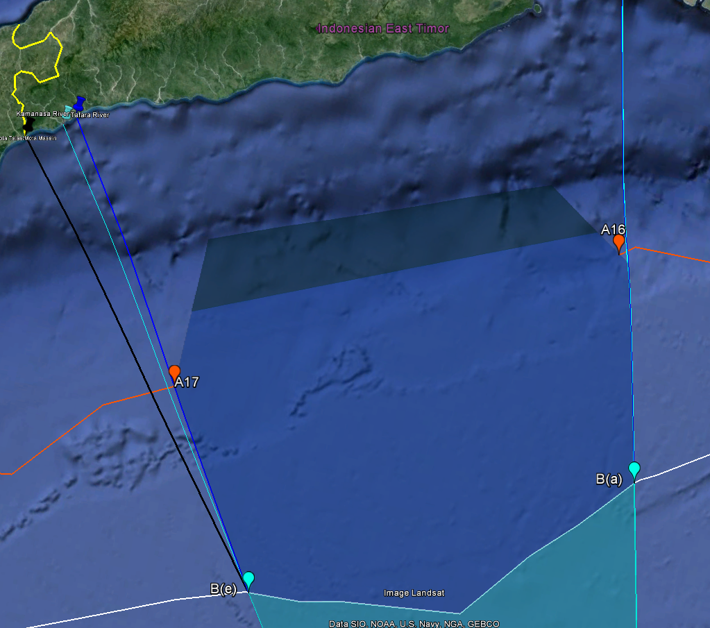
The lateral boundaries of the Zone (marking the width of the Zone as it runs east-west) are more arbitrarily drawn than the longitudinal boundaries. The western lateral boundary of the Zone is particularly odd, as it is in fact two different boundaries. Unlike the eastern boundaries for Zones A and B (which are roughly identical) the western boundaries for Zones A and B show a marked and unexplained divergence. It appears that the western boundary of Zone A (in royal Blue) was established by a line drawn from the mouth of the Kamanasa River through the point of A17, which then terminates where it meets the median boundary between Australia and Indonesia (in white), to intersect at the point marked by point B(e). The western boundary of Zone B (in cyan), although roughly similar, runs at a different angle from Zone A’s boundary. Zone B’s boundary appears to have been established by drawing a line from the mouth of the Tafara River through point B(e), which then terminates where it meets the 200 nautical mile line of Timor’s EEZ (the southern border of Zone A), to intersect at the point marked by B(d):

Eastern and Western lateral boundaries of Zone of Cooperation, extended to shore of Timor
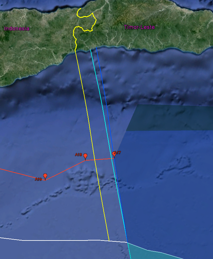
(The points marking A(c) and A(n) are not pictured, because their coordinates are the same as points A16 and A17 from the 1972 Seabed Treaty. Note that A16 and A17 are the bookends to the “Timor gap”.)
The logic behind the placement of the Zone’s western boundary is not immediately apparent. It is often said that the western boundary is a “simplified” equidistant line that divides the territorial seas between Portuguese Timor and Indonesia, but there is reason to question this assumption. First, the western lines simply don’t appear to be an equidistant boundary, as it is claimed; it may perhaps be a “simplified” line of equidistance, but if so, it’s an unintuitive approximation of that. Second, the boundaries of the Zones are unerringly straight; they draw direct line into the coasts, and not angled in a manner that would suggest they are following an organic boundary division. And, third, based on the historical context, it makes little sense for the lateral boundaries of the Zone to have been drawn along a line of equidistance. In 1989, there was only a single sovereign on the island of Timor, and that was Indonesia. The purpose of the Timor Gap Treaty was to resolve the division of an undelimited maritime boundary between a sovereign that held the entirety of the north and a sovereign that held the entirety of the south; there was absolutely no need to calculate the boundary of two adjacent sovereigns on the northern side, or to have the division of the Zone reflect that. The Zone was plainly a compromise, as shown by its Trough-marked northern border and 200nm southern border, and there is no reason to assume that the western and eastern border were not also based on pragmatic considerations — as opposed to reflecting the sovereign territory of the state of Timor-Leste, which no longer existed.
And from the maps, it does very much appear that the western boundaries had been drawn in reference to geographic features on Timor. Both the Zone A and Zone B western boundaries line up directly with river mouths on Timor’s shore:

If the western boundary of Zone B (cyan) and Zone A (blue) were extended all the way to the Timor shore, the boundary of Zone B would intersect with the mouth of the Tafara river, while the boundary of Zone C would intersect with the mouth of the Kamanasa river.
The Zone established by the Timor Gap Treaty is therefore arbitrary, in that its boundaries were not delimited on the basis of an objective and independent body of international law, but instead were delimited on the basis of negotiation and compromise between Australia and Indonesia. They are pragmatic, rather than legal. As a result, the western boundary of the Zone was in no way intended to reflect the territorial waters that modern-day Timor-Leste would be entitled to, as provided by international law. Using the Tafara and Kamanasa Rivers to establish the western boundaries for the Timor Gap Treaty was an arbitrary but convenient way to establish the Zones of Cooperation, as it would allow the Zone’s coordinates to be determined based on an existing geological feature, rather than a random coordinate.
But these two rivers have no independent signficance as boundary markers. Their use demonstrates that the Zone’s boundaries are not based on Timor-Leste’s territorial boundaries.
The Massin River, which lies to the west of the Tafara and Kamanasa rivers, is a far more signficant reference point. The mouth of the Massin river (called the Mota Talas) marks the boundary between the state of Inodnesia and the state of East Timor. As a result, if the Zones of Cooperation had been drawn to delineate the territorial sea of what was then Portuguese Timor, then the western boundary of the Zone should lead directly to Mota Talas.
But it doesn’t. Below, Mota Talas has been marked with a black pushpin, and the boundary line from Mota Talas to point B(e) has been marked in black, showing what a boundary from Mota Talas would look like, compared to a boundary from either Kamanasa or Tafara:
Angle of hypothetical boundary drawn from the Timor-Leste/Indonesian border through the point marked B(e) from Timor Gap Treaty (in black)

Close-up of the theee rivers where western lateral boundaries converge on shore of Timor
So why draw the western boundary from Tafara or Kamanasa instead of Mota Talas? This distinction doesn’t make a tremendously huge difference in terms of total sea area; by using the boundary drawn from Tafara (marked in cyan) instead of the boundary drawn from Mota Talas (marked in black), a total of approximately 131 square nautical miles are excluded from the territory of Zone A. This means those 131 square nautical miles were within Australia’s sole sovereign area, rather than within an area that Australia and Indonesia had joint authority over.
131 square nautical miles is a relatively tiny area, however, compared to the Zone’s total territorial expanse. Given this marginal difference, then even if the western lateral boundary of the Zone should have been drawn from Mota Talas instead of Tafara, does it result in any real prejudice to Timor-Leste?
Well, yes. One reason why Australia may have chosen to draw the boundary from Tafara and Kamanasa — and not Mota Talas — becomes immediately apparent if the markers for the Laminaria-Corallina gas fields are displayed on the map:
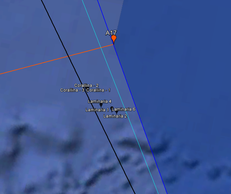
Close-up of western boundary of Zone A, showing boundary line of Zone A (blue), boundary line of Zone B (green), and a hypothetical boundary line drawn from Mota Talas line (black). Note the convenient placement of Laminaria-Corallina wells, which would all have bee enclosed in the JPDA/Zone a had the boundary been drawn from the actual border of Timor-Leste and Indonesia. By drawing the line instead from two rivers farther along Timor-Leste’s coast, Australia can claim 100% of the tax revenues from the Laminaria-Corallina fields.
By establishing Timor-Leste’s territorial sea based on a point that falls wholly within Timor-Leste’s land territories, instead of basing it on the point that marks it boundary with Indonesia, Timor-Leste’s territorial sea excludes what was, in 1989, a very substantial oil field. In the 25 years since the Timor Gap Treaty, the Laminaria-Corallina oil fields have been all but tapped dry by Australia. Billions of dollars in natural resources that would have fallen within Zone A (and therefore shared with Indonesia) instead fell entirely outside of the Zone, and were used exclusively by Australia.
It could be a coincidence, that the boundaris of the Zone were established so that it just barely excluded the Laminaria-Corallina oil fields. But you can understand my skepticism. With billions at stake, that kind of convenient boundary drawing can be explained better by design than by happenstance.
In any event, it is clear that the Zone does not reflect what Timor-Leste is actually entitled to, because it is not based on Timor-Leste’s sovereign borders. If the western lateral boundary of Timor’s EEZ and territorial sea were to be re-drawn today on the basis of its actual territory (and — if I were in charge of the world — the one that I would I draw), a more appropriate division might be provided by the proposed boundary depicted below, in yellow. This way, Timor-Leste’s territorial sea actully aligns with its land boundaries (marked in the thicker yellow line):
Alternative western lateral boundary between Australia, Indonesia, and Timor-Leste (yellow)
This boundary preserves the angle established by the Timor Gap Treaty (and the Timor Sea Treaty) — which is not terribly far off from the angle of an equidistant line dividing the territorial seas of Indonesia and Timor-Leste — but it shifts the maritime boundary’s starting point over, so that it aligns appropriately with Mota Talas.
This proposed division also reflects the equidistant-influenced 1972 Seabed Boundary. Although the 1972 line was drawn to reflect Australia’s “natural prolongation” claim, the ultimate boundary was a compromise between a continental shelf division (which lies along the Timor Trough) and an equitable division based upon the shape of the Timorese and Australian coast line. The boundary line that runs between points A18 and A17 of the 1972 treaty partially reflect the “straightening” of Timor’s coast (where the coast stops running southwest-northeasth and begins to run west-east), and this straightening in the coast begins just before the border of Indonesia and Timor-Leste. This would also suggest that a more appropriate maritime boundary between Timor-Leste and Indonesia would fall somewhere west of A17 and east of A18, instead of on A17 itself.
The Eastern Lateral Boundaries of Zone A and Zone B
The eastern lateral boundaries of Zones A and B are nearly aligned, with angles that have only the barest degree of difference. The boundary has been established along a line that starts in the middle of the island of Leti (at mile 4 of an 8-mile island), and then moves southwest until it meets the 200nm boundary south of Zone B. Its angle is somewhat arbitrary, though; instead of drawing the eastern boundary through A16, as might be expected, the line intersects the 1972 boundary between A16 and A15. In some respects, it could have been drawn to represent a “simplified” line of equidistance. But, once again, as with the western boundary, there is only an approximate resemblance to the hypothetical equidistant line, and it has a more pronounced convergence away from Timor than would be expected, if the boundary were based on a territorial division between Indonesia and Timor-Leste. And, also like the western boundary, there is no reason to expect that, in 1989, Indonesia and Australia would have established the eastern boundary of their Zone of Cooperation so as to reflect the appropriate territorial division between Australia, Indonesia, and a nonexistent third state.
The eastern boundary may also have been established simply to mirror the angle of the western boundary, and provide for a more symmetrical Zone. Whatever the reason, the eastern boundary goes from Leti Island on a westerly angle to where it intersects the median line, at the point marked by A(m) (which is now point M from the Timor Sea Treaty), before finally terminating at the 200nm line, at the point marked by B(b).
But the angle created by starting the boundary at Leti is unequitable and arbitrary when applied to a territorial division between three sovereigns. When the eastern boundary was created, that wasn’t an issue, since all of the islands were Indonesian; Leti served as a convenient geographical base to use as a reference point in plugging up the Timor Gap, and the boundary did not need to take into account the competing claims of a sovereign state across the channel from Leti. A more equitable line might be something approximately along the boundary line shown below, in yellow. This boundary represents an equidistant division beginning at the median of Leti and Jaco, but which angles back towards the west to represent the effect of Indonesia’s straight baselines. The territory covered by the Sunrise IUA has also been shaded in, in orange, for reference:
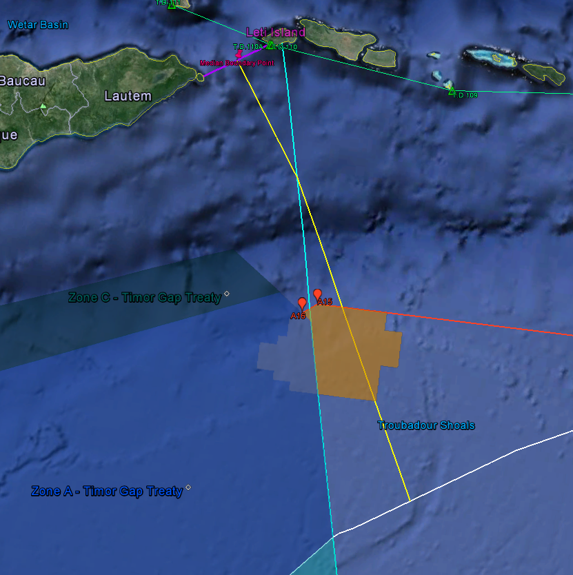
Alternative eastern lateral boundary between Australia, Indonesia, and Timor-Leste (yellow)
Once again, the result of this change is small, but significant. Timor-Leste’s territory would encompass an approximately 70% of the Sunrise-Troubadour field region, as opposed to the 20% that falls within the JPDA today.
Eastern and Western Lateral Boundaries of Zone C
The lateral boundaries for Zone C (which converge closer towards Timor) are almost entirely arbitrary: they were established by taking the northern-most point on the Australian coast that lies to the east of the Timor gap (Melville Island) and the northern-most point that lies to the west of the gap (Long Reef) and then drawing a line from those geographical features through points A16 and A17, respectively. Those lines then terminate where they intersects with the Timor Trough (northern boundary of Zone C).
The western and eastern lateral boundaries of Zone C are shown below, with extensions drawn to the northernmost points of Long Reef and Melville, for reference:

Lateral boundaries of Zone C, drawn from Melville Island through A16 to the Timor Trough (eastern), and from Long Reef through A17 to the Timor Trough (western)
Timor Gap, All Lateral Lines
Finally, by extending the lateral boundaries of Zone B south, to where they meet the Australian coast, and north, to where they meet the coast of Timor, you can see the truly inequitable shape created by the Zones of Cooperation (and, subsequently, by the JPDA):
IV. Timor Sea Treaty (2002) and the Joint Petroleum Development Area
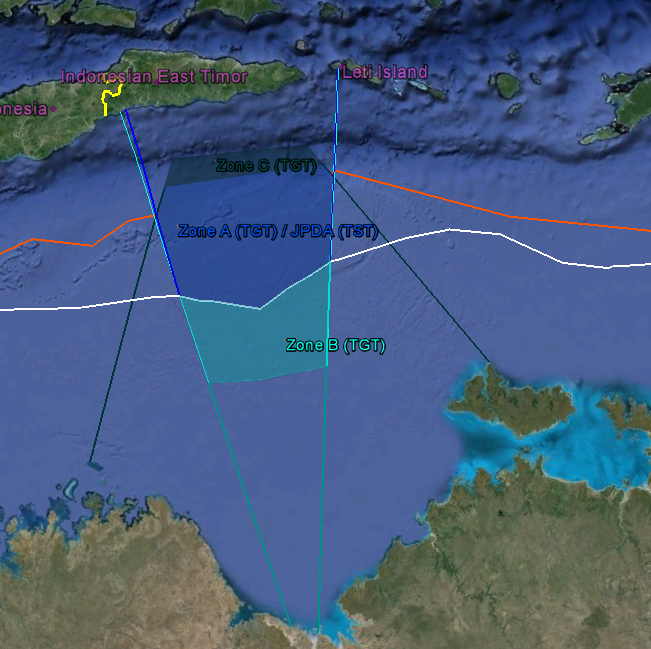
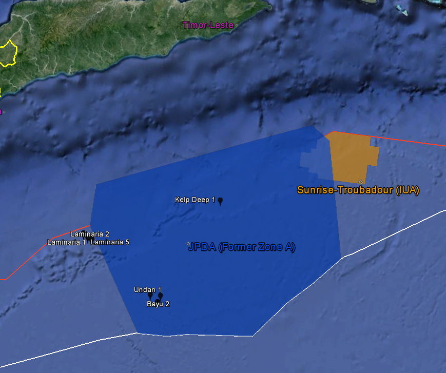
Following Timor-Leste’s independence, Timor-Leste and Australia negotiated the Timor Sea Treaty. The TST essentially preserved Zone A of the TGT, shown below in royal blue, and provided for a division of control and tax revenue from petroleum production in that area. Following the TST, the status of the areas to the east and west of the JPDA that lie between the red and white lines remained uncertain.

V. The Sunrise IUA and CMATS (2006)
Following the boundary lines established by the TST, approximately 80% of the resource-rich gas fields known as Greater Sunrise remained in no-man’s land. Although the 20% of Greater Sunrise that lies within the JPDA would be governed by the TST (with revenues split 90%/10% in Timor-Leste’s favor) the other 80% of Greater Sunrise was unaccounted for by the TST. Under the Certain Maritime Arrangements in the Timor Sea treaty, which put it into place the earlier (but unratified) Sunrise IUA, a Greater Sunrise area was established, shaded in orange below, which provided for Timor-Leste and Australia to split the revenues from production within the area 50%/50%.
VI. The Lowe Opinion
The Lowe Opinion (2002) is a paper that was prepared at the behest of an energy company that had previously been divested from any opportunity of developing the oil and gas fields in the Timor Sea. Following Timor-Leste’s independence, corporations who were not among the select consortium that had an enshrined right in the Australian-issued leases (i.e., everyone other than Woodside and its JV buddies) had a financial stake in encouraging Timor-Leste to take a more aggressive stance in negotiations with Australia regarding the delimitation of the seabed boundary.
The Lowe Opinion was intended to encourage Timor-Leste to do just that, and, in order to show Timor-Leste the full extent of what was potentially on the bargaining table, it proposed an alternate plan for establishing the maritime boundaries between Timor-Leste and Australia that was tilted in Timor-Leste’s favor. It did so primarily by drawing the southern/northern boundary along the median boundary (in white), and then re-drawing the lateral boundaries in an, err, aggressively equitable fashion, so that Timor-Leste had more maritime territory to the east and west of the JPDA. The proposed lines from the Opinion are shown below in neon pink:

The proposed maritime boundaries of the Lowe Opinion
The eastern lateral boundary shows two hypothetical lines — one is a median line drawn equidistant between Timor and Leti’s coasts, while the line farther east is drawn so as to give only a partial effect to the Leti Islands, owing to their smaller size.
The Lowe Opinion does correctly point out that points A17 and A16 from the 1972 Indonesian-Australian Seabed Boundary are arbitrary points that reflect what was convenient to the drafters of the Timor Gap Treaty, rather than reflecting what international law would provide for. Although the Opinion’s western lateral boundary is overly generous, and just as arbitrary as the JPDA’s current western boundary, it does represent a good faith claim Timor-Leste could have asserted when going into negotiations with Australia. (And it is certainly far more reasonable, and far more in good faith, than Australia’s own starting position was.) The eastern lateral boundaries proposed in the Lowe Opinion range from fairly reasonable to, at the most extreme, a fairly unreasonable discounting of Indonesia’s own territorial seas. The effect the Lowe Opinion’s proposed eastern lateral boundaries would have, if adopted, would be to place all, or substantially all, of Greater Sunrise within the EEZ of Timor-Leste.
-Susan
fn1. It is interesting to compare the boundary between Zone A and Zone B with the boundary that was later established by the 1997 water column agreement between Australia and Indonesia. The 1997 water column agreement (which divides the Timor Sea for purposes of the water columns, but not the natural resources in the seabed) established a median line that was identical to the PFSEL for every point outside of the Timor Gap. Inside the Timor Gap, however, the 1997 water column agreement does not follow the PFSEL — instead, it follows closesly to the Zone A-Zone B boundary, except the coordinates of its points run slightly to the north of the points that establish the Zone A-Zone B boundary.)

Thank you very much Susan for sharing this information with us… best. Lucas
Susan, I have looked at this site many times over the past few years. You refer to Median Lines and assume they must be straight. Since coastlines are not straight, I do not know how any straight line can be a median line. I believe that a line of equidistance is a better principle. A line of equidistance is a line that consists of all the points of equidistance between two sovereign countries. This principle is refered to in US Federal Register and is the principle used in modern boundary disputes see reference below.
See this example applied to the Timor Sea eastern boundary: http://www.slideshare.net/ChrisHarris36/points-of-equidistance-and-eez12a-copy
“Federal Outer Continental Shelf (OCS) Administrative Boundaries Extending from the Submerged Lands Act Boundary seaward to the Limit of the United States Outer Continental Shelf,” Federal Register, January 3, 2006 (Volume 71, Number 1) pp. 127–131.